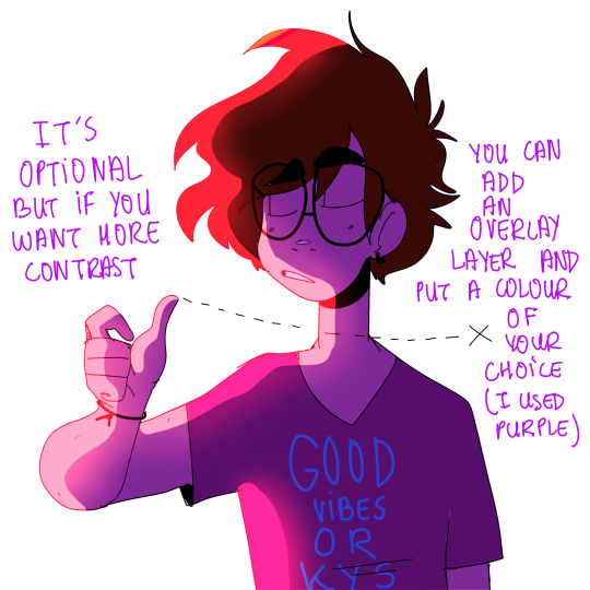
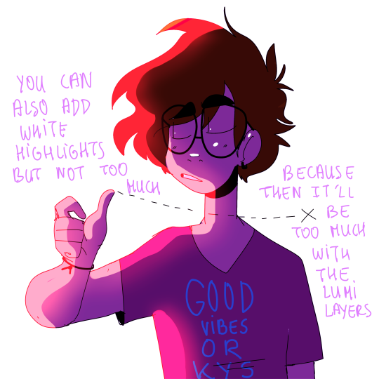
Years ago I once mentioned to a coworker at a theatre where I was interning that my boss was bi (he was out, I wasn’t doing anything I shouldn’t) and she said “Oh! He sometimes shops at the other market!”
I almost fell over laughing at the expression, and I reported the conversation to my mum later. She picked it up and would joke about it for like, YEARS after. It became a running joke in our family, the expression “He shops at the other market.”
This ended up being REALLY funny about five years later when we were trying to find a grocery store on a family road trip and ended up buying what we needed from a grocery store with a big sign out front reading BI-MART. We pulled into the parking lot and I leaned over to my mother and said, “This is the other market he shops at.”
One of the most frustrating things about learning a language is the inevitable “say something in that language!” Something I like to do in response is say a tongue twister, which is impressive and a good way to practice pronunciation, anyway. Here are a few I’ve learned:
ばすがすばくはつ [basu gasu bakuhatsu] (3X) What it means: Bus, Gas, EXPLOSION! Note: I learned this from a particularly cute Japanese woman, who liked to throw her arms up to imitate the explosion as she taught us.
あおパジャマあかパジャマきパジャマ [ao pajama aka pajama ki pajama] (3X) What it means: Blue pajamas, red pajamas, yellow pajamas. Note: I have been told the color order on this doesn’t matter, as long as you say it the same way all three times.
となりのたけがきにたけたてかけた。たけ たてかけたかったからたけたてかけた。[tonari no takegaki ni taketate kaketa. take tate kaketakatta kara taketate kaketa.] What it means: I leaned on the bamboo fence next to me. The bamboo fence leaned also onto me. Note: This one is especially fun at parties. One of my coworkers thought this sounded particularly hilarious with an American accent, although that’s probably because she was used to my normal speaking, which I do try to keep close to actual Japanese.
すいたそうしゃじょうしろシャツじゅんしゃしゃさつじけん。[Suita soushajou shiro shatsu junsha shasatsu jiken.] What it means: The crime of the shooting of a white-shirted associate in a Suita railyard. Note: my fiance’s father taught me this one, and I’m only 90% sure I’ve mastered it. As I can’t find evidence of its existence on the internet, you’re just gonna have to trust me.
These are called “Hayakuchi Kotoba (早口一言)” in Japanese. I like to learn the words first, then worry about correct intonation and rhythm second in this case. It makes the longer ones especially easier to memorize.
I wonder about other languages’ tongue twisters…
I wanted to update this with a new one: すもももももももものうち。[Sumomo mo momo mo momo no uchi.] What it means: “Plums and peaches are both in the peach family.”
basic japanese high school schedule for you, fic writers
students attend class from monday thru saturday, with saturday being a half day. sundays are off
the high school day usually runs from 8:30am to 3pm, but many students stay after for after school clubs or attend cram school in the evening
the school year runs from april to march with a summer break come the end of july. first term is from april to july, second term is from september to december, and third term runs from january to march
your favorite high school anime doesn’t have separate classrooms for no reason. japanese students don’t rotate classes like american students do; instead, they have a fixed classroom and class number (i.e., 3-A), and the teachers do the rotating
they also don’t have the same classes every day
they do still have homeroom teachers; however, “homeroom” is more of a class meeting at the end of the day rather than at the beginning
the students are required to help clean the school at the end of the school day before clubs start
school uniforms are a thing for high schoolers. dress code used to be much stricter but recently they’ve allowed more basic alterations to the uniform
please stop writing them like american schools you’re embarrassing yourself
Addendum from someone who works at Japanese public schools:
* There are sometimes separate rooms for classes like science labs, music, and home ec. While students stay mostly in the same classroom all day, it’s not like they don’t have facilities for subjects that need special equipment.
* Classes have anywhere from a 5 minute to 15 minute break between periods, the most common being 10 minutes. Students are wholly unsupervised during this time as teachers often go to organize materials or go to the staff room. This is usually when bullying or other mischief goes on.
* There is no auxiliary staff to speak of. There are no adult hall monitors, security guards, substitute teachers (*), cleaning staff, or secretaries. There is a principal/headmaster, a vice principal/deputy headmaster, and a single coordinator for the staff – two if they both work part-time. There is a school nurse, but they are not required (so usually aren’t) to be a certified nurse. If the school serves meals there is a coordinator for the kitchen staff (the former working full time and the latter part time).
* After school clubs for junior and senior high school often meet every day, especially if they’re a sports club. They also are expected to come to the school for special practices or activities during spring, summer, and winter vacations. Non-sports clubs are not exempt from this. Only elementary school age children or very rich upper class kids have the luxury of a vacation to themselves without being at school most of the break.
* Uniforms are for the vast majority of junior and senior high school students. Very elite private high schools will allow more casual dress, but often their students prefer the uniform to show off where they go to school. However, it’s the reverse for elementary school. Public elementary school does not require a daily uniform, though there is a gym uniform and a standardized swimsuit. Very posh private elementary schools require a set of uniforms and it is the most expensive thing a child will probably wear in their life (costing upwards of several hundreds to over a thousand dollars).
* Saturday school was technically abolished in the early 2000s, but PTAs and school boards nationwide did not agree with this and so we’re left with voluntary on paper, but actually mandatory special activities and seminars on Saturdays.
* Student cleaning of the school can also be done around midday recess, not just at the end of the school day.
* Weekly, twice monthly, or monthly morning assemblies take place to inform students of upcoming events, showcase student accomplishments (both individual and team achievements), and/or touch on issues at the school both positive or negative.
(*) Substitute teachers exist as in a teacher will be brought in to cover a maternity leave or a teacher leaving halfway through the year (nearly unheard of unless they have an extreme medical problem or have a mental breakdown). If a teacher is sick for a day or up to a week, the other teachers are supposed to rotate stepping in to teach for the absent teacher’s class. There is no system of on-call substitute teachers like in the US or UK.
Every city provides an array of service, residential, and industrial
functions. How these services are arranged in relationship to one
another is what we call the urban structure, or the land use structure.
There are three modern models used to describe these structures, which were based on observations of the North American city, as well as some additional models that help explain unique situations and antiquity. However, it is important to note that not every city falls into one of these models. These models attempt to explain larger organizational trends of people/services seen in existing cities. They do not dictate ultimate city form. In
other words, you couldn’t use these models to decide whether or not
your street patterns are gridded or irregular, you couldn’t use it to
decide whether or not your city is planned, circular, square, or organic
in form. You could design a grid city that fits any of these models
for example! City form is only influenced, not dictated, by your urban structure.
Thus we can conclude that an urban structure model is more theory on
the spacial relationships goods, services, and people need and have to
one another in a city, and city form is your physical implementation of
these ideas.
I am going to explain each model and then point out the Take-Aways, or the critical content and concepts that will help you in deciding and designing your city. Consider it your TL:DR version.
So! before we delve into this, I want to explain what a city ‘core’
is, mostly because it gets referenced quite a bit when discussing the
models. A city core is the area of the city where the flow of people, culture, goods, services, information, etc is most concentrated. Often times it is considered the center of business. Cost of living is the highest here, as is the magnitude of activity. Today we may refer to this as the ‘downtown‘ of a city, or the ‘hub‘ or the ‘heart‘.
Examples in antiquity are the Agora in Athens or the Roman Forum, and
Central London in the modern. Cities can have one core or several,
depending on many different factors.
So now that we have an idea of what a core is, lets look at these models!
Concentric Zones
In this first model, the city is organized in a series of rings emitting concentrically outwards from the Core. As you can see above, that core of the city makes up the entire first ring, followed by (2) a ring of industry & factories, (3) a zone of transition intermixing working class housing & industry, (4) working–class residences, (4) middle–class residences, and (5) the commuter zone. When applied generally, you can see this either in play or in the past in many American and European cities.
In real-time practice, these zones would encroach somewhat on each
other, and would need to respond to any cultural influences and demands
made by the terrain. As with all models, it needs a reasonable transportation network
(good roads, trains, etc). However, in a Concentric Zone Model, most
often the transit system is expensive and use is thus limited to the
wealthy.
The Core & Inner Rings of Chicago
This model was developed by sociologist Ernest Burgess in his observation of cities in the American pre-car, industrial age (specifically
Chicago). This model was based on the (at that time) observation that
the poor did not have access or money to bring themselves in and out of
the city every day (because transit was expensive!), while the wealthier
wanted fresh air & space.
Here is the concentric model overlay of Chicago, as Burgess observed in 1920:
If you are interested in seeing how Chicago developed over a span of 100 years, this site
has some really great images and a quick overview! If you do take a
look, notice how each year Chicago expands concentrically outwards, as
does the rail road. This animated graphic
goes through changing median incomes over the last 40 years, where you
can still see present the observations Burgess made–a strong economic
center, surrounded by poorer industry & working class residences,
followed with the middle & upper classes always remaining even
further outwards.
The First Take Away: This model really hits home the influence of a core, whether it is business, legislative, or religious. A core is a major organizational component of a city–knowing where your core (or cores) are in your city will help you decide your next major moves.
Though this model was developed in reflection of the early industrial
city, where you had concentrated inner city poverty and outer wealthy
suburbs, you can always adjust these relationships and ring definitions as you build your own city. And these relationships are
different, depending on the city you look at. It is easy to make the
case for a wealthy inner city that surrounds the core, with
manufacturing and poverty towards the outer rings (See: New York, See:
Ancient Aachen).
This model also has a single core, with social groups and industries arranged around it in a series of sectors or districts
that are more defined by their relationship to major transit lines. In a
way, this is just an evolution of the Concentric model–where, as a more
complex and affordable transit network emerges, the city too responds.
The lesson here is that city form follows transit lines and that you need to think about who uses those lines: Industry?
Low Income Residents? Commuters? Furthermore, Higher income
neighborhoods tend to follow higher ground, extending along non-industry
river fronts, along transit lines as well, and usually towards open
country. This model also acknowledges that there is high-income
residents interested in living close to the core.
An example would be Sunderland, England, as diagrammed below; read more here.
The waterline here is a major transit line and you can see industry
hugs this waterway. Lower classes in turn hug the industrial belt,
where they would find a source for work. Middle and upper classes expand
towards the open but still have relative access to the CBD (Central
Business District/Core)
The Second & Third Take Away: This model is a little more realistic when it comes to more industrialized cities. People and industry pretty much always follow transit systems.
That doesn’t mean you cant have several transit systems in place. Maybe there is one train line for industrial use and one for commuters?
Maybe you have some major public boulevards for carriages used
primarily by merchants and high-income and offshoot pedestrian paths for
the low-income residents? Service roads and commercial streets?
This model also acknowledges that people of all income classes like to live closer where they work.
I am adding a map of Bruges, though it never really underwent any
sort of industrialization. Here you can see how the city has expanded
along major transit lines and water ways–the most along the major water
channel, which happens to have a significant amount of industry
surrounding it as you move north.
Districts/Sectors with Multiple Nuclei
This model states that cities are composed of several cores-religious cores, industrial cores, business cores, cultural cores,
etc. Around each of these cores conglomerate related services. For
example, a university core may attract well-educated residents,
pizzerias, and bookstores, whereas an airport may attract hotels,
low-income residences, and warehouses. Incompatible activities will
avoid clustering in the same area. (1)
This obvious acknowledges that different functions require different amenities. But, it also that a city requires a really strong transit infrastructure. This is most likely a system to exist on a large scale where cars or some other form of rapid transit are in place.
Los Angels is a great example of this, since the city is so large.
One can even make an argument for NYC–with a cores around Wall Street,
Times Square, Central Park, and Downtown Brooklyn–though modern NYC is a
little more complicated when it comes to analyzing form due to all the
planning & regulation that has influenced development over time.
The Fourth and Fifth Take Away: Larger cities tend to have several cores.
Consider cores for religion, culture, ethnic backgrounds, businesses
and trades, classes and government. Though there may be one central
pulling force for all of them, they all most likely also have their own
centers of operation. Additionally, different cores/functions require different amenities and have different users.
Garden City by Howard
Additional Models and Structures
So the previous three were all conceived upon the studying of North
American cities. Thus you may find this doesn’t always apply in Europe,
modern day 3rd worlds, and elsewhere. (If applied generally, these cities may fit). I want to briefly touch upon a few other patterns and models as well.
Irregular / Organic Pattern
Favela, Rio De Janeiro, Brasil
Most likely you’d see this occurring now in third world countries,
where there is no rhyme or reason as to what is getting built where and
people are building for themselves. There is no clear plan for expansion–it just happens on
its own when the population needs it to. City form can take all sorts
of an appearance, industries can get mixed quite heavily (so there
really is a complete free for all) but you still will most likely see a
separation of high and low income.
Planned Models
Brasillia, Brazil
I wanted to include planned cities because they appear all the time throughout history. A planned city is often
the product of a planner taking an urban structure (existing or
invented) and allowing it to dictate city form. These types of cities
have been in use for thousands of years–with deliberate premeditation to zoning, land use, ritual, administration, and critical city systems.
We will delve heavily into these later on in separate articles as well. But the take away here is that, if you wish, you can take (or design) any urban structure / model and allow it to inform all your decisions about placement of housing, streets, infrastructure, and services. A city can be completely preconceived, and there are examples of planned cities going back thousands of years.
Timgad, Roman City 100AD
Mohenjo-Daro, 2600 BCE
Evolving / Patterns over Time
Europe and Middle Eastern cities each have a lot of history behind
them, which of course often gives them no easily identifiable city
structure today (though many can broadly fit into one of the
models above). These cities have often evolved out of previously large
towns or ports and have seen their borders continually expand.
Originally, many were built for the pedestrian (vs the more modern
cities in North America for the cart, car, & commerce). Their form
and centers are also defined strongly by their original
hook—Islamic cities tend to be centralized around religious grounds,
whereas many of the cities in England are centered around their ports
and rivers. With time they expanded to include other services, and
perhaps other cores, but this ‘old city’ still remains present and
active.
The Take Away? All cities evolve over time.
The longer the city has existed, the more likely there are multiple
designers, cores, and ideologies of planning at play, the more likely
you will have a mix of modern & ancient infrastructure and materials
(dirt, cobble, and paved roads all within radius, for example, or the old city vs the new city). Additionally, older cities are more likely to be pedestrian friendly, with pedestrian-only streets, plazas, and public space.
You can see here in this map of Bruges, the old city in pink and the
new city extents in green, growing along major transit paths.
Milan, 1600s
And Beyondddd….
Erich Kettelhut – Metropolis
Gotham City Concept by Anton Furst and Nigel Phelps
I’m sure there are more theories of city structure out there–there
are definitely numerous theoretical and unrealized designs for cities
floating around in dusty tomes of history and the deep recesses of the
net. I’ll eventually touch upon some of those, but as to general city
structure, this should be a good place to jump off from. Realize that
you can create your own city structure and logic to things. These
models above are based on the observable reality here today on this earth.
Overall Take-Aways:
These structural models are simplified ways of
looking at what are ultimately very complex systems. These are a good
place to start if you are unsure where to begin, but don’t be afraid to
have anomalies and to allow your city to grow organically as well. No city that exists today can perfectly fit any of these models, and neither really should yours. 🙂 Mix, match, and make it work.
These models don’t completely dictate form. City form, street patterns, and architecture are all left to your personal discretion. You can design a gridded city for any of these models, for example.
Your city has a history, and you need to know it if you are going to design it.
As above, how old is the city? Did it start as a city (preconceived)
or was it originally a town? Was it a series of villages and towns
joined together through expansion or conquest? Were there many
designers, over many years, or just one? Or none?
Know your city profile. What is its major hook–religion? commerce/trade? legislative? This will help you identify city cores.
People and industry pretty much always follow transit systems.
In cities, the poor are more likely to live close to where they work when there is a poor/ineffective/non-existent/expensive transportation system in place. This is why in NYC, for example, middle and low income residents live in the outer boroughs, because transit is cheap and effective!
Having fresh air, space, good light are attractive to the wealthy. If you want them in your center, then maybe your center is garden-city styled, gated, or the likes.
The wealthy do not want to live near low income housing, usually due to its poor quality, and they do not want to live near industry.
Old cities are more pedestrian friendly, Modern cities more transit friendly.
All cities evolve over time and can shift between models in this evolution.
‘Mixed Income’ residential areas are naturally uncommon, but they do exist and are planned and executed often through law.
Knowing what your transit system is and where your critical arteries lie will help you design your city structure.
Different industries and services have different needs, both in terms of labor supply, service supply, and access to transit. We are going to discuss this in the next article!
Exercises & Questions
The following questions will help you figure your city form.
When was your city established?
What major topological features intersect your city?
Was your city conceived as a city or did it grow forth from a town? If
it grew forth from a town, you probably will have an ‘old city’
district, or some sort of indicator of the old. You also will most
likely, though not always, have your core somewhere located in that old
city. Its infrastructure will also be a little more messy, and the
city most likely will be more pedestrian friendly.
Has there been any urban renewal? – Specifically,
major projects to protect or replenish different parts of the city. Cities subject to massive urban renewal projects often see a shift in
where their populations live and do business.
How large is the city? — Area & population?
What age of technology was your city built in? — For example, cities built prior to cars tend to have small streets and pedestrian only ways (think tiny, winding streets like this one in Toldeo) whereas cities built for cars tend to be a little more spaced out, with every street being car accessible. You just wouldn’t get those tiny winders in cities designed or conceived in a post-industrial age.
What infrastructure is available today?–what age of
technology are you in? Cart & Wagon? Trains? Cars? Space ships?
These all need to be accounted for and your city form needs to change
from when it was first built to today (or it doesn’t. see: Venice)
What is your city hook? Culture & Entertainment
& Tourism? Trade & Banking? Administrative activity? Religion?
This will help you figure out what your city cores are. You can have
one or several or all of these being important, if you wish. But be
careful, too complex can be messy. All of these of course will exist in your city on some level, but here you are looking to decide what the biggest driver(s) is. We will discuss this in depth later.
What major industries operate in your city? Do they
need their own districts? Do they have any topographical needs? What
services do they need to be adjacent to? For example, a butcher in a
medieval city probably should be downstream from residences, so their
pollute doesn’t affect drinking waters. A university will most likely
be established near the city archives or library. Factories that employ
cheap labor are also probably close to low-income housing. etcetcetc.
What is the social stratification in your world/city?
Do the rich loathe the poor or take pity? How many classes or tiers are
there in your society? Do they mingle or do they avoid one another? Are
there orphanages? Slums? Places where each class does not, or can not,
go?
What is the racial stratification in your world/city?
In many cities, people of different ethnic and racial backgrounds tend
to stick together, especially immigrant populations. Look at
NYC–traditionally, the following neighborhoods popped up to serve
migrant populations: Little Italy (Italian), Harlem (African American),
Spanish Harlem (Mexican), Chinatown (Chinese), Five Points (Irish) etc.
Your city probably has some version of this too.
Are there any major ceremonies that all portions of the population acknowledge?
For example, say you have a city who whenever a new king is crowned,
there is a big parade. Say the King gets crowned in the major church
and then proceeds back through the city to his castle (all the way on
the other side of the city). It would make sense, then, for there to be
a major boulevard connecting this church to the castle. So
figure out if you have any important ceremonies, religious or military
celebrations, etc and decide if your city should respond accordingly.
Are there any major roads running near by or to the city?
Most likely they should be intersecting your city, because most major
cities are points of intersection–roads, trades, cultures, etc. These
roads also will become your major boulevards, transit pathways, etc.
Bonus Reading and Sources:
Burgess E.W.
(1924)”The growth of the city: an introduction to a research project”
Publications of the American Sociological Society, 18:85-97
Hoyt H (1939): “The
structure and growth of residential neighborhoods in American cities”
Washington DC; Federal Housing Administration
Harris C D and Ullman E
L (1945), “The nature of cities” Annals of the American Academy of
Political and Social Science 242: 7-17
Rodwin, L. (1950) “The Theory of Residential Growth and Structure”, Apprasial Journal, 18, pp.295-317
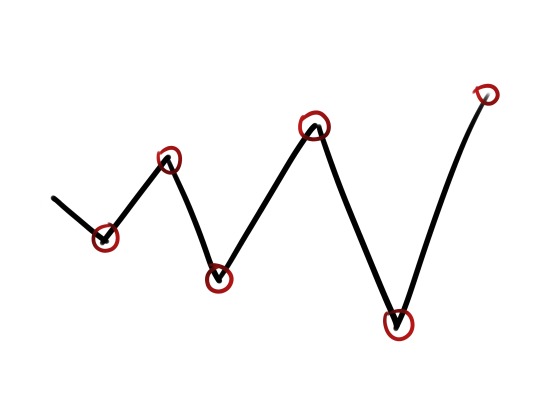
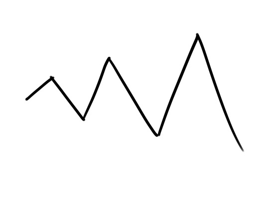
I’ve learned this method years ago and I’ve been using it ever since. The zigzag plot creator starts like this:
An crescent zigzag.
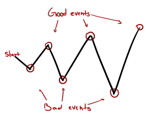
You can have as many up and downs as you want. I’ve drawn six to keep it simple. Alright, this zigzag is your storyline and every corner is an important event that will change everything:
Every down represents a bad thing happening to your main characters, taking them further away from their goal. Every up is a good event, taking them closer to their goal:
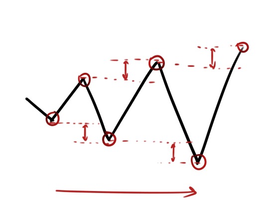
So, when the zigzag goes down, something bad must happen. When the zigzag goes up, something good must happen. The reason why we drew a crescent zigzag is because every down must be worse than the previous, and every up must be better than the previous. As the zigzag advances, events become more serious and relevant.
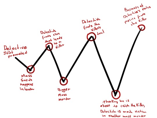
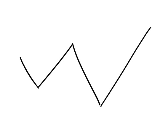
Let’s apply the zigzag method. My storyline is a detective trying to catch a serial killer in a futuristic city. Minutes later, this is what I’ve got:
Start: Detective, our protagonist, is just promoted
Down #1: Mass suicide happens in town, detective gets the case, the whole town thinks it might have been a religious suicide act, but detective suspects that someone single-handed killed all those people
Up #1: Detective finds clue about a possible killer
Down #2: A bigger mass murder happens, a true massacre, it’s a definitely a murder
Up #2: Detective finds the killer’s trail
Down #3: Thinking he is ahead of time, close to catching the killer, detective ends up dead in another mass murder
Up #3: Because of his notes and discoveries, the police is able to find the killer before they leave town
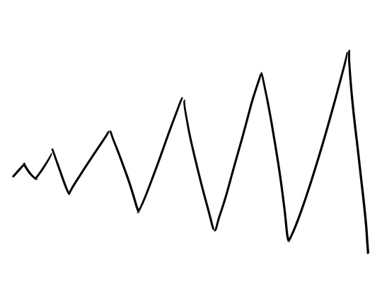
From this point on you can play with zigzag as much as you want. For example, changing the orientation of the zigzag for a bad ending:
Lots of ups and downs:
Or just a few:
It’s up to you (see what I did there?).
You can plot any type of story with the zigzag method. It’s a visual and easy process for a very complex task.
I put together a skin tone reference sheet for you guys! All tones except Reyes, Genji and
Reinhardt
are pulled from the reference sheets provided. I pulled the tones for the above three from their throwback skins, or in
Reinhardt‘s case, one where I could see his face.
As it says in the image, the first tone is the HIGHLIGHT – use sparingly! Second tone is the BASE TONE/MID TONE – this is their main color! The final three are their increasingly deeper shadows.


